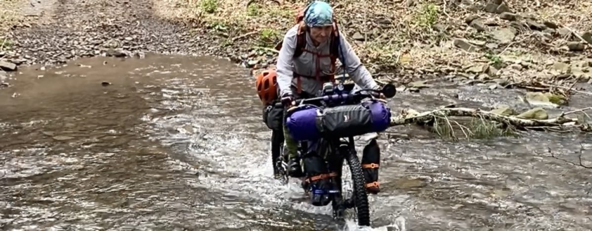
Standing waist deep in the swamp, I study the forest on the other side, my eyes searching for a trail. At 5’1” with freakishly short legs, water that would be knee deep on the other 13 in this race–all men–this water is close to waist deep on me. I am one of fourteen who began this race on September 11, 2016 and the only woman competitor. It’s now Day 6 and the race has already been won. But buggy water aside, I am in no mood to quit.
The Adirondack Trail Ride (TATR) is a 584.3 mile race through the remote and rugged wilderness of northern New York. Caches (or food drops) and support crew are not allowed in this self-supported bike-packing race through the remote and rugged terrain of the Adirondack Park.
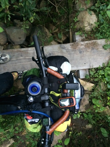
I was drawn in by the adventure and, while it took me a good deal more time than the first place finisher, I would not have traded my adventure for the world. What follows is my account of some of the experience, including at Day 6, my adventure in fording a swamp with a fully loaded bike, affectionately named The Beast, weighing upwards of 60 lbs.
Day 1
Race Day started on a brutally hot morning. I kissed my husband, Mike, goodbye as he set off on his race. I was jubilant thinking that I had a fantastic adventure in front of me, as I settled in near the end of the racers. This state Park is a 6 million acre preserve, uniquely structured with private land, villages and towns interspersed within this constitutionally protected wilderness tract. In this “park” water is plentiful if you have a filter, but food and lodging are scarce.
Racers carry what they can, including sleeping bag and possibly a tent, and primarily camp in the wilderness, although there is the random offer of a bed on those occasions when we depart the woods for prepared food or to service our bikes. A GPS, paper maps and good bike lights are necessities. For safety, a spot tracker monitors the racers via satellite connection, transmitting each individual’s location to a map that is available online to anyone who is interested.
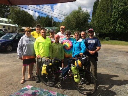
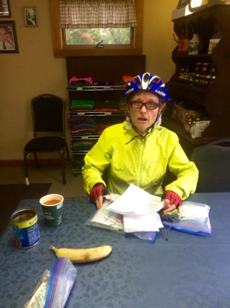
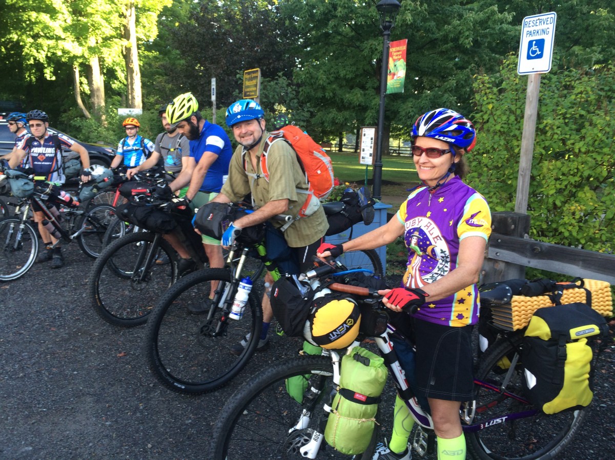 At the start line
Different levels of protection are afforded this rugged terrain, with some sections off-limits to anything but hiking, so the race developer, Mikey Intrabartola, used single track and snowmobile trails, and dirt and gravel roads to create the race framework, but added pavement as well to keep the racers on public land.
Day 2
I was thrilled to wake before dawn and start pushing my bike along the Pine Orchard trail, not willing to risk riding and slipping on the roots and rocks in the dark. By 7 am I was 2 miles in and realized I was working on some serious saddle sores.
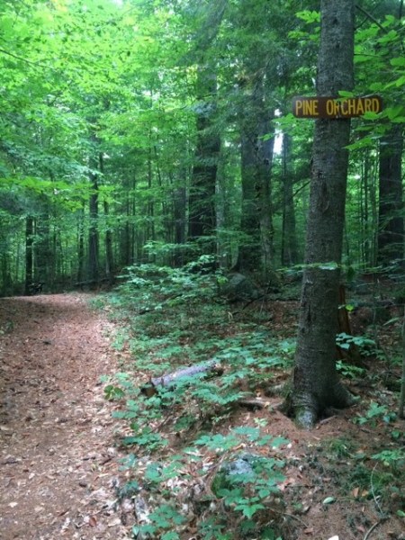
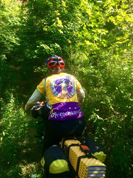
This shot makes Pine Orchard look easy
Pine Orchard is where most everything is uphill and what isn’t feels like it. I’d pedal a few hundred yards and then be off the bike, pushing over enormous logs for the next hundred; repeat. I developed a side-stepping method to inch the bike up steep hills that I simply couldn’t push The Beast up.
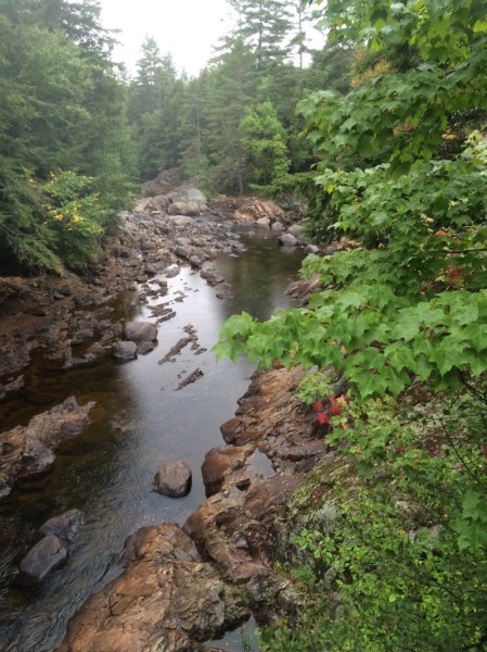
By 4 pm I had made it through the 11.5 miles of tortuous trail, plus an extra 2 miles when I missed a turn. I ate a freeze- dried meal and pitched my tent across from a “camping prohibited” sign but with a great view of Griffin Gorge.
Day 3
I awoke to rain, waited, and then started riding in the rain. My first access to cell phone service was 3 miles from Speculator. I had a string of messages from folks frantically “looking” for me since I was “lost.” Hmmm…..I knew where I was. Confusion set in for me since I had no idea my spot tracker had malfunctioned and my little pink icon had disappeared from the online map. By the time I hit Speculator, 13 dedicated friends and family members “found” me and took me to lunch.
I took a motel room and called it a day.
Day 4
Two hearty breakfasts later, I set off mid-morning.
Where’s the trail?
I only made it 35 miles to Indian Lake by dark.
Day 5
This was a day of unbridled excitement as I arrived at my next resupply. I’ve taken great care to stay well-hydrated and eat something every hour.
In the Village of Inlet I felt strong and decided to ride into the night on some logging roads. This first attempt at night riding started off well as I pedaled along the Tobie bicycle trail, a dirt, double track that is very manageable in the dark with lights.
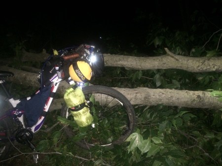
Just another obstacle
Then my bike light failed and that was followed by gunshots at 11 pm as I turned onto a logging road that would take me north to Big Moose Station. Since I couldn’t see well enough with my headlamp to find a camp spot (and I wasn’t sure I wanted to camp in the midst of the rapid gunfire I heard) I walked, or trotted, my bike—for 12 miles.
My pace had quickened that night each time the gunshots broke out and I rattled my bear bell constantly, calling out, “Hellooo. Please don’t shoot. I’m just passing through.” And then, “Just passing through on my bike but broke down. Please don’t shoot.” Eventually I made it off the logging roads, finding a place to camp at 2:30 am, mentally and physically drained.
Day 6
Since I hadn’t pitched my tent, I scrambled to pack when it started raining at 5 am. I was still happy to be on my way, despite the rain and the deep dirt on the newly graded road. Then I swerved hard to the right to avoid a car at the crest of a hill and went down hard. The driver pulled The Beast off me and helped me to my feet. I hurt but the bike seemed to be in good order. I continued on carefully, unable to use my right hand much because of the pain. I had a vague realization that my hand injury might take me out of the race. As I pushed through the difficulties of the day though, my hand gradually became an afterthought.
This is the Day of the Swamp that started this story.
Here I stand, waist deep. Fortunately, I had the presence of mind to leave my bike at the edge of the woods so my camping gear at least will be free of the swamp stench.
A valley runs between my edge of the woods and the forest on the other side of the swamp—about 600 feet away. I use my GPS to find the mileage to some feature marked as “The Tunnel,” on my National Geographic-NY map and on the race-course. I don’t know what this “Tunnel” is, but I’m so close. It’s just over a mile but it might be swamp all the way across, and I don’t see a path through it.
Do I push through anyway? But if I go off the race-course, I’ll be disqualified. I also know how remote this area is and how dangerous it is to go off-trail in the Adirondacks, a 6 million square mile swath of thick woods. This is how people die. I call it quits on this side of that nightmare.
I turn back toward the woods, panicking when The Beast, my trusty bike, is nowhere in sight. I push my fear down and circle methodically until I catch a glimpse of the bright yellow panniers. Sheer relief.
Despite being more careful about noting where I leave The Beast as I continue pushing through brush, searching for some path that can get me back on the race-course, I “lose” my bike again. After this second scare, I swear I will keep my bike with me no matter the hiking difficulty.
Soaked and smelly from swamp water, I start backtracking to the massive logging debris I dragged my bike over earlier in the afternoon. I’m on the side of a clear-cut mountain covered in dead wood and slashings. Every direction looks the same.
My brain is slowing as I’ve exhausted all the obvious choices out of this mess when I notice I’m losing daylight. In another panic I realize it’s 6:45 pm and I need to pitch my tent.
No tent “spots” exist on this mountain of irregular and jagged wood, and rocky and rutted ground, so I start scratching out a space. I pull wood away, move rocks and place other wood strategically to construct as flat an area as possible…..I think about how my GPS has not been so helpful for me….but I’m not yet thinking clearly enough to consider why I’ve gotten into trouble with it.
I use everything but my food bags to cushion under my ground pad in an attempt to “flatten” things out. There is no place to string up my bear bags so I drop them as far away from my tent as I dare, place the bear spray at my side, and before I drop off to sleep the thought comes to me…..This is Reality TV.
Most of my family and friends know I despise Reality TV, but I feel a connection with some of the scenes I have watched. Is anybody out there watching me? Can they see me?
Day 7
At sunrise, with a clear head and renewed sense of purpose, I use my paper map and compass to plot my strategy. My water is nearly gone….I went through so much yesterday afternoon. I hear a plane overhead and wonder whether my friend Dan will come looking for me in his plane if I don’t turn up soon.
It didn’t rain overnight, but thick fog has drenched everything. I mark my campsite since all terrain looks the same in every direction, and off I go. I’ll limit my search for the race trail to three hours since I may need a half-day to get out and find a road.
I trudge though logging debris and start off toward the other side of the mountain. I see rough signs of a couple of dirt tracks created by the loggers of course, but that gives me new hope. Maybe the Bryant Bridge Road IS up here and it simply isn’t marked. I’ve hit a few “roads” on this race-course with no markings, even though they are on the map.
I methodically explore each, but all remnants of rutted, log-strewn roads disappear. I’m getting close to the three-hour deadline I’ve allotted when I’m suddenly back at my camp spot. The panic kicks in as I realize I’ve gone in a circle—all this work to make no progress at all.
“Time to go back the way you came in, Jody.” I listen to that voice and off I go. I’m determined not to make the same mistake I made 30 years ago when I was trekking solo in the Himalayas. I got lost trying to find a short-cut to a village and stubbornly persisted in looking for it, spending two nights on top of a ridge without food or water. A snowstorm came in on the second night so I had trouble following even the easy path, the long path along the ridge, the following morning. I push that experience from mind and focus on navigation.
I explore a few “potential trails” as I work my way out. I certainly wouldn’t want to go through all this only to miss my trail now! I climb back down the mountain of logging debris and study the landscape one more time.
“If this is where the race-course goes, then the navigation skills required are beyond me.” With this thought, I start backtracking. I saw the Oswegatchie Educational Center just off-course yesterday—I’ll call the race organizer from there.
Back on Course
From my description, the folks at the Center immediately know where I’ve been. Despite what I was seeing on my GPS, I had been up on Bald Mountain. I needed to go just a little further along on the road to see the huge Microburst Boulevard sign, which would lead to the Bryant Bridge Road. I learn the following day that the “Boulevard” on that sign is a misnomer since it’s simply another dirt road on state land.
Bill, the director of the Center, says, “It’s not every day we get a true Adirondack explorer stopping by…,” and he and his crew insist I stay the night and get a fresh start in the morning. They likely see the exhaustion that I don’t recognize in myself. Several meals, a hot shower and a good night’s sleep make all the difference.
Day 8
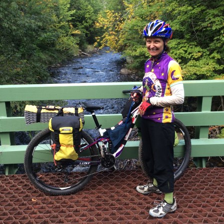
Squared away and ready to go! 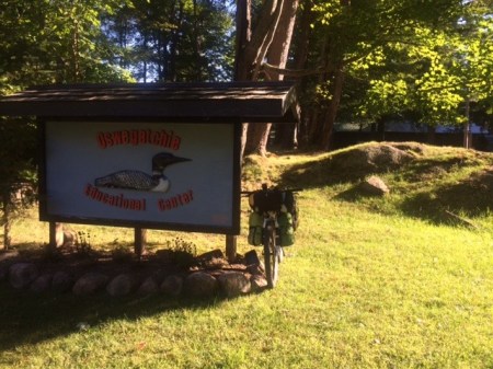
Before I leave, Bill gets the spot tracker map up on the computer and I learn then, that 6 of the 14 racers had scratched a few days into the race. Rob Cook has already won this 584.3 mile wilderness mountain bike race and the remaining competitors (including my husband, Mike Feldman) are poised to finish within 1 to 3 more days: all while I’m struggling to reach Star Lake at mile 215.
After pedaling away from the Center, I make my way off Bald Mountain Road and this time find the dirt roads and then the trails that will take me through the wilderness to Star Lake.

The Adirondack “Boulevard” that I missed the previous day!
With about 15+ miles of remote terrain remaining before I hit that village, a support clamp shears off, breaking my rear rack. My bike is too heavily loaded but a rack with panniers was the only way to fit camping gear on my small-framed bike.
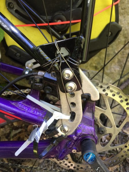
I “MacGyver” a fix with some wire and continue, riding as carefully as possible over the rocks and logs.
While the trail is rugged, it’s nothing compared to Pine Orchard—tortuous Day 2 of my ride. All I keep thinking now is, “Pine Orchard is the toughest section on this race and I got through that….”
B.J. at the local hardware store in Star Lake helps me put a new clamp on my rack, I replenish my supply of turkey subs and avocados at the convenience store and I’m back on-course, heading into the northern reaches of the Adirondack Park.
Day 9
I wake at dawn in a hidden clearing to a flat rear tire. It’s something everyday. And I really don’t want to change a flat tire right now so I pump it up and hope it holds. It does as long as I top it off every few hours.
The trail to Wanakena
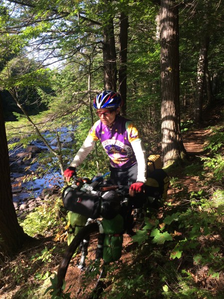
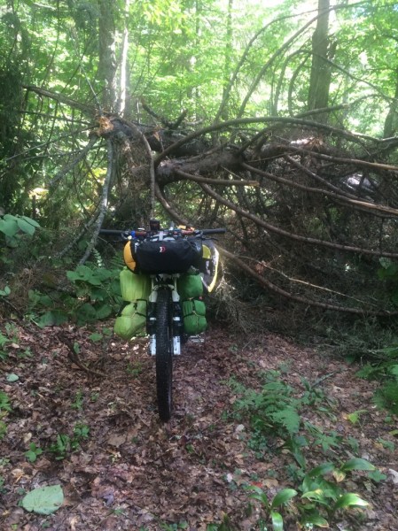
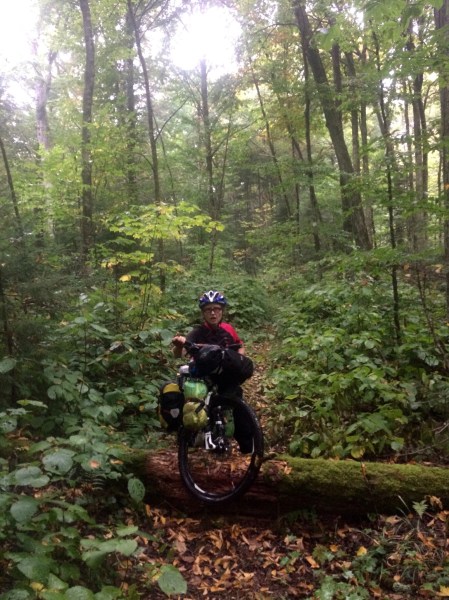
Every day involves trail finding, bushwhacking or a disappearing trail, as well as hike-a-bike. Much of the dense forest is clogged with blow-down, necessitating an on-the bike, off-the bike routine to get over or around trees—trees that are often waist high on me. Mountain biking in the Adirondacks typically involves hike-a-bike but it’s a staple on TATR course, and with a fully loaded bike.
Hike-a-Biking with The Beast
This day is more of the same until I break out of the woods in the late afternoon, into the rain again, and am greeted by a couple at the trailhead. Car lights are flashing, the horn is honking and they jump out of the car, shouting my name. Turns out a friend from Boston told my story to her cousins who live nearby and they’ve been following me online. Tom and Maggie become instant friends and graciously offer me a place for the night. Off I go, trailing their car, excited not to be camping in the rain. Other dinner guests they invite convince me I really do need to change that flat tire out.
Day 10
Refueling at a convenience market
I rely much more on my paper maps now since I’m no longer so confident about my GPS. This slows me down for sure. I camp in the dark.
Day 11
Three miles down the road, a bear cub scampers across my path. No time for pictures: bear spray in hand, I freeze waiting for Mama Bear.
The cub scampers back and forth across the road and eventually meanders further along the road (which just happens to be the route I’m taking) until disappearing from sight round a curve, all by himself. Still no Mama Bear. I don’t want to follow that cub, but I’m also not giving up on this race.
This is one bear scenario my husband and I had never discussed in my preparation for this adventure. Hands shaking, I try to call and then text Mike for advice, even though I can see there is no cell service.
Eventually a woman drives up and we agree that she’ll trail me in her car for a few miles at my speed. About a mile down the road, I round another curve and the bear appears about 20 feet in front of me.
My “trail angel” quickly puts her car in between me and the bear, and the three of us proceed along the road, almost together. We decide it’s not prudent to pass our furry friend with me on a bike.
We can’t be sure, but it seems likely Mama was an early casualty of Bear Season, which opened two days prior. In a couple of miles, the little guy finally bolts to the woods and my trail angel continues to shadow me for a few more miles until I feel comfortable again. As soon as I have enough nerve to stop for a break, but with hands still shaking, I move my bear bell to my helmet where I can maximize the noise.
Adirondack spring water stop
That afternoon I pull into Paul Smith’s College and anxiously await the opening of the dining hall for dinner. Re-energized and resupplied with as many potatoes and brownies as I can wrap in napkins, I ride on, into the dark to pitch camp just west of Debar Mountain.
By this time, I’ve learned that I’m the only racer still out here. All remaining competitors have finished but that doesn’t dampen my spirits. I always planned to finish my race despite my speed, or lack of it.
Day 12
The next morning I spend some much needed time with my GPS. I can now make “my tracks” a color in contrast to the race-course color. I can also zoom in for detail that allows me to see my turns before I pass them! I will no longer ride a mile or two just to determine if I’m still on-route. I knew the GPS was a weak point for me—had I devoted some time to it pre-race, I would have saved myself days as well as a boatload of headache.
Wet roots take me down for crash #4. Thankfully, I’m not hurt and a little later I’m loving the dirt and gravel roads, a welcome change from hike-a-bike trail riding.
The loop to the south of Rt. 26 along Thatcherville Road is stunning.
As I cross the North Branch of the Saranac River I meet Steven, an advertising executive temporarily escaping New York City. He very kindly shows me a natural spring where I fill my water bottles and in return I listen to his exasperation with city life and about his year-long journey into the Adirondacks a few years back to save his soul and sanity. The Adirondack Park seems to be that kind of sanctuary for so many.
Normally I’m no fan of riding pavement on my mountain bike but by this point in “my race,” I’m hoping for it at every turn and the rest of the day is just that. Of course when I hit the pavement today, Gillespie Drive toward Whiteface Memorial Highway is a killer climb. No pictures, or words, can convey the sheer magnitude.
I’m fully prepared for eight miles of steep uphill so I am ecstatic when I find the last few miles to be a steep downhill into Wilmington and a motel parking lot. My race progress has not provided many opportunities for lodging and the North Pole Motel is a haven. The laundry room finally allows me to eradicate that swamp smell!
I later hear the tracker map showed me camping at the North Pole Wine & Spirits Shop, but I am comfortably tucked in at the motel. Spirits of any kind would be a race stopper for me!
Day 13
I warm my drying clothes in the morning sun and then I’m finally off at 10:35 am to start Day 13. The coffee is just too good and, somehow, I’m thinking my ride will be downhill to Essex.
It’s not downhill to Essex, but feels instead like it’s straight up. The 49,000 feet of climbing on this race is beginning to sink in.
The upside of Day 13: I start Map #4! Although I still have a distance to go, that only leaves one more map!
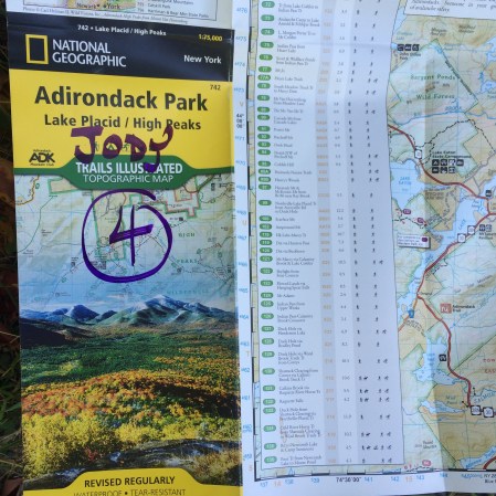 Map 4 out of 5
The downside of Day 13: My bike rack breaks – again. This time it’s a clamp on the side bolstered by only two clamps instead of three. I take out my wire once again, add two zip ties for good measure, and then try to ride “gently” down the rutted dirt roads. At this point I decide that if it doesn’t hold, I’ll stash one of my panniers in the woods and return for the goods post-race.
This day includes several miles of hike-a-bike trail but it comes late in the day for me so that’s always tough.
On a footpath – of sorts – enroute to Essex
Once again, I don’t stop to take photos during the worst of it! I didn’t in Pine Orchard, the most tortuous section on the race, or in the logging mess up on Bald Mountain….I just put my head down to plow through and never think to take pictures at the time.
The trail seriously disappears once and I end up with hundreds of some kind of “forest thorns” on my shorts and socks that take nearly an hour to pick off later that night.
Day 14
I’m up and at Ernie’s Market for a breakfast sandwich and coffee by 8. On to Mountain Spring Road and up, up, up and more up. Near the top I run into a couple of town workers sawing brush and a busload of inmates from the shock incarceration program hauling it away.
A little further along I meet up with a couple of guys grading the road. I lock into cautious gear so I won’t go down in the deep dirt. Crash #3 for me had been on a recently graded dirt road and that hand injury threatened to stop my race. I don’t want a repeat.
I’m sluggish on this long, slow ride with numerous steep climbs, but eventually make it to North Hudson and then the steep 13 miles uphill to the trailhead for Cheney Pond at dusk. Lester Flow and across the Boreas River—in the morning.
As I set up camp in the dark, I realize I’ve already camped solo 7 of my 13 nights out here—2 nights lodging from trail angels who offered to put me up and 4 nights in a motel.
When I first committed to TATR, I thought the race would take me anywhere from 14 to 21 days. I’m simply not built for speed; yet, as I trained and strategized, I reduced my estimate considerably—10 to 14 days. Although I didn’t voice it aloud, I really thought I’d come in under 10 days. It’s a little disappointing.
Day 15
I wake up several times between 12:30 and 3:30 am and each time it’s raining pretty hard. The pit in my stomach tightens. If this rain brings the river up waist deep on me, I’ll have a problem…those freakishly short legs again.
The river crossings had been my biggest worry on this race (along with bears and running out of food) and as I sit in my tent listening to the downpour, I consider the alternatives. I know there is a ride-around if the river becomes dangerous to cross, but everyone else rode this way and I want to ride the same course.
Although it’s still raining when I pack and start riding, the rain has not brought the river up. In fact, it’s quite low and I easily cross. I marvel at how much stronger I’ve become as I push and carry my bike across.
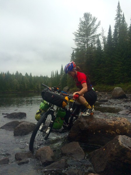
The Boreas River
The trail from here is difficult, devolving into steady hike-a-bike with one log after the next to climb over with my bike. Still, it’s no Pine Orchard from Day 2!
Then, Hoffman Road is also tough–a rock garden several miles long. “Road” is another misnomer. Eventually I come out into Olmstedville and I have some hot soup in Sullivan’s convenience store. From here it’s on to Heads In Beds, a quaint hostel in North Creek, where I’m able to dry out my camping gear from the night before.
That night is my toughest physically, probably because for the first time on the race I’ve not followed my strict regimen of eating every hour and rehydrating as soon as I’m off the bike. I also should have changed into my compression socks after crossing the Boreas River.
Day 16
I lose myself in my thoughts as I ride. In fact, my final two days bring greater reflection to the race for me, perhaps because I feel myself slowing down.
Day 16 puts me on the home stretch, but I don’t make it home. I do, however, break into Map #5–the final map! Oven Mountain Road, Paint Bed Road, Ski Hill Road, and Henry Westcott Road…..trails to more dirt roads to trails again.
Somebody with a sense of humor on Paint Bed Road!
I suffer as I continue up, up, up. I take my mind off the grueling climbs by thinking of the people I’ve met along the way. I smile remembering a dinner I had in a remote bar where a small crowd of locals all wanted their pictures taken with me.
Eventually, I’m on W. Stony Creek Road, I find state land and pitch my tent. I’m famished.
That night there’s a cold snap and today’s exhaustion carries over as I drag through the next day as well.
Day 17
I’m up and moving early but once I come to frost covered fields, I stop to make a fire to warm up. On to Baldwin Springs and the Arrow Trail, which in my misguided enthusiasm, I had ridden a few months back and recommended be included in this year’s course. Whatever was I thinking! I could’ve been home by this point.
Back out on dirt road for a short bit, and then over Tenant Creek to the final section of trail.
As I struggle to keep riding, my reflections continue……
Many times during my race I’ve marveled about Michelle, the only person who finished last year. I’m so impressed she did so in 13 days since I know she had to bushwhack a several mile stretch that has since been cleared. Kudos also to the eight guys who finished TATR 2016 so quickly!
Now, on I ride to the E. Stony Creek Trail, where my friend Rich has ridden in to meet me for my final few miles of dirt.
I walk around my last rock garden, huck my bike over the last log and get to pavement in Hope Falls….so close to home. Several more miles into Northville, the start and finish of TATR, and I ride into Waterfront Park and turn off my spot tracker at 16 days, 8 hours and 36 minutes. A well-earned, last place finish!
A friend at the finish line asks how this race compares to other challenges in my life. Obviously, I had a whole lot of time out there to reflect on just about everything so I know exactly where TATR stacks up.
It’s one of the top three most difficult things I’ve ever done. The other two: self-supported solo treks in the Himalayas for six weeks at a clip and traveling overland through Africa for a year on my own. Each of those undertakings was pre-cell phone, pre-digital age and my only connection to the outside world was through postcards and the now antiquated aerogram.
While my Himalayan treks were physically demanding, locals were out there so I never felt absolutely alone in my endeavor (except for that one time I got lost for three days—but that’s another whole story!). While my Africa journey was mentally demanding, I wasn’t dealing with a prolonged physical challenge.
TATR, however, pushed me physically every day and I had to dig deep, mentally as well. Food, a camp spot, navigation and arduous climbs were my focus every day. It wasn’t until I finished that the elevation stats for TATR became clear for me. 49,000 feet in climbing on the race—that’s a little more than the elevation of Mt. Everest and Mt. Kilimanjaro combined.
While I haven’t climbed Everest, I did trek close to the base camp in 1987 and I climbed Kilimanjaro in 1975. I can say with certainty that neither challenge includes rugged obstacles like those in the Adirondacks.
